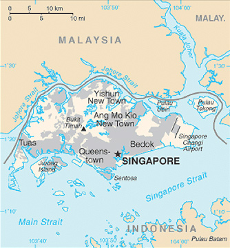
Source: Singapore, CIA World Factbook.
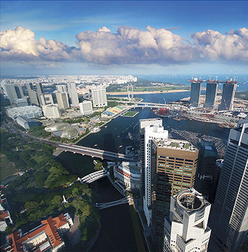
Source: Another window view from 60th floor of UOB Plaza 1-Singapore, williamcho, Flickr
|
Source: Singapore, CIA World Factbook. |
Source: Another window view from 60th floor of UOB Plaza 1-Singapore, williamcho, Flickr |
Using the strategic geographic features identified in the map and image above, which of the following statements is most likely true?
A. The straits surrounding the nation make it a center for trade and transportation.
Correct! Straits and rivers are strategic geographic features that encourage trade and transportation.
B. Significant barriers have offered military protection throughout Singapore’s history.
Incorrect. Military protection comes from barriers like mountains or deserts, none of which are present in the evidence presented.
C. Its extreme, cold climate has helped isolate it from her neighbors.
Incorrect. Singapore’s location in Southeast Asia and proximity to the equator give it a warm climate.
D. Its network of straits and rivers has inhibited the development of the Singapore economy.
Incorrect. Straits and rivers often help economic development, and the city shown is built around the waterways.
Use the information in the box and your knowledge of social studies to answer the following question.
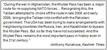
Which of the following statements best explains why the author believes the Khyber Pass to be the most important pass in history?
A. It serves as the primary trade and commerce route between Afghanistan, Pakistan, and Russia.
Incorrect. Notice the purpose of the pass during the war with Afghanistan.
B. It has been an important pass throughout history because of the availability of resources in the highlands of Afghanistan.
Incorrect. Look again at the reasons why the Taliban wanted to take control of the Khyber Pass.
C. It has historically been regarded as a cultural hearth of the region because of the religious significance of the pass.
Incorrect. Think about why the Pakistan government was upset when the Taliban gained control of the pass.
D. It is a strategic transportation route that has been repeatedly used for defensive and military purposes.
Correct! Territorial control of the pass by NATO and then by the Taliban shows the strategic importance of this defensive transportation route.
Use the chart and your knowledge of social studies to answer the following question.
Commercial Maritime Traffic, 2007
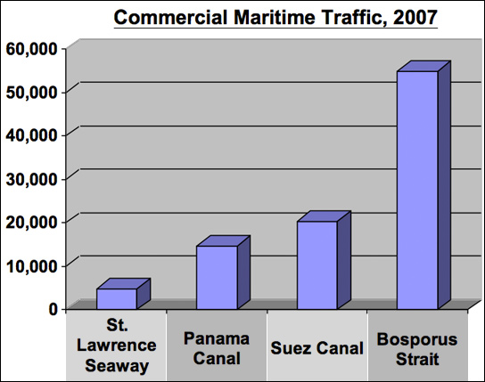
Which of the following conclusions can be drawn based on the information from the chart?
A. The economy of the Middle East region is dependent upon the availability of water transportation routes.
Correct! Almost 75,000 cargo ships travel through these two water passages each year.
B. The Panama and Suez Canals are the most heavily traveled water passages.
Incorrect. Look again at the chart and find the areas where commercial traffic is the greatest.
C. The most strategic waterway passage in the western hemisphere is the St. Lawrence Seaway.
Incorrect. Compare the traffic numbers for the water passages located in the western hemisphere.
D. Egypt is the most vulnerable to environmental disasters from leaking cargo ships and tankers.
Incorrect. Notice the amount of cargo traffic that passes through each of the water routes.
Use the map and your knowledge of social studies to answer the following question.
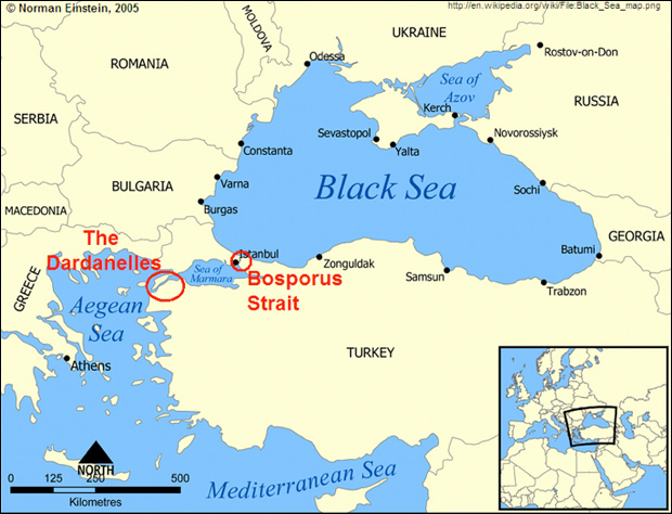
Which of the following statements best explains why The Dardanelles and Bosporus Strait would be important to Russia?
A. Without navigating through the straits, Russia would be unable to trade.
Incorrect. Look again at the map and examine what geographic feature is located west of the Turkish Straits.
B. The straits are located along a chain of highlands that provide protection to Russian naval ships.
Incorrect. Remember that water passages provide a means of trade and transportation.
C. The Turkish Straits provide Russia access to the Mediterranean Sea.
Correct! The Turkish Straits provide a way for Russia to trade and transport through the Mediterranean Sea.
D. Russia’s trade with the Ukraine is dependent upon travel through the straits.
Incorrect. Notice that the Ukraine is located along the coast of the Black Sea.