Use the maps and your knowledge of social studies to answer the following question.

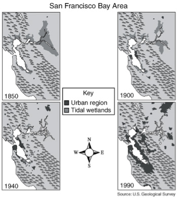
These maps of the San Francisco Bay Area support the conclusion that —
A. as the urban area increased, tidal wetlands diminished
Correct! In 1850, there is only a small area that is urban, but by 1990, urban areas have increased dramatically into former tidal wetland regions.
B. urban leaders supported wetlands preservation
Incorrect. There is no information on the maps to answer this question.
C. as wetlands diminished, urban population became less dense
Incorrect. Populated areas became denser as the wetlands diminished.
D. population growth occurred mostly in mountainous areas
Incorrect. Most of the mountainous area is unpopulated.
Use the map and your knowledge of social studies to answer the following question.

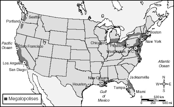
A megalopolis is an urban area made up of adjoining cities and their suburbs. The feature shared by all the magalopolises on the map is that they —
A. are located along the East Coast
Incorrect. Megalopolises are also located along the West Coast as well as the Gulf Coast.
B. extend through two or more states
Incorrect. There are more than two states that have megalopolises.
C. are adjacent to bodies of water
Correct! The megalopolises are located along the various coasts, oceans, and Great Lake systems.
D. are located in river valleys
Incorrect. River valleys are not represented on this map.
A stream that flows into another larger stream is called a —
A. tributary
Correct! A tributary is a body of water that empties into a larger body of water.
B. estuary
Incorrect. An estuary is where fresh water and salt water mix.
C. headwater
Incorrect. Headwaters are the waters that originate at the surface water’s source.
D. wetland
Incorrect. The wetlands are located where the land meets water.