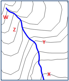
The topographic map below shows a river running through it. According to the shape of the contour lines around the river, where is the elevation highest?
A. W
Correct! On a topographic map, contour lines “point” upstream when they cross a river or stream.
B. X
Incorrect. Remember on a topographic map contour lines “point” upstream when they cross a river or stream.
C. Y
Incorrect. Remember on a topographic map contour lines “point” upstream when they cross a river or stream.
D. Z
Incorrect. Remember on a topographic map contour lines “point” upstream when they cross a river or stream.
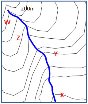
In the topographic map below, there is a contour interval of 10 meters. What is the difference in elevation between the contour line at X and the contour line at Y?
A. 10 meters
Incorrect. If the contour interval is 10 meters, the space between each line represents 10 meters. There are 8 lines between X and Y. Try again.
B. 20 meters
Incorrect. If the contour interval is 10 meters, the space between each line represents 10 meters. There are 8 lines between X and Y. Try again.
C. 40 meters
Incorrect. If the contour interval is 10 meters, the space between each line represents 10 meters. There are 8 lines between X and Y. Try again.
D. 80 meters
Correct! If the contour interval is 10 meters, the space between each line represents 10 meters. There are 8 lines between X and Y so that is 80 meters.
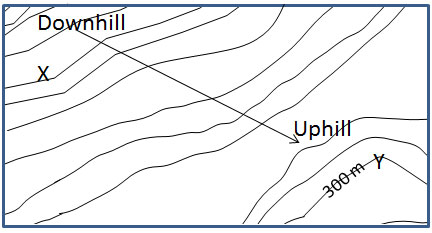
In the topographic map below, there is a contour interval of 20 meters. What is the elevation at X?
A. 280 m
Incorrect. If the contour interval is 20 meters, the space between each line represents 20 meters. We know that point W is at 200 meters and that X is downhill from W. Try again.
B. 360 m
Incorrect. If the contour interval is 20 meters, the space between each line represents 20 meters. We know that point W is at 200 meters and that X is downhill from W. Try again.
C. 40 m
Correct! If the contour interval is 20 meters, the space between each line represents 20 meters. We know that point W is at 200 meters and that X is downhill from W. There are 8 spaces between W and X so that is a total of 160 meters different. 200−160=40.
D. 100 m
Incorrect. If the contour interval is 20 meters, the space between each line represents 20 meters. We know that point W is at 200 meters and that X is downhill from W. Try again.
What is the feature located at X in the map below?
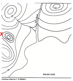
A. Hill top
Incorrect. A hilltop is represented by a closed circle. Feature E is a closed circle with hachure marks. What does a closed circle with hachure marks represent?
B. Depression
Correct! A depression is represented by a closed circle with hachure marks.
C. Lake
Incorrect. Feature E is a closed circle with hachure marks. What does a closed circle with hachure marks represent?
D. Stream
Incorrect. Feature E is a closed circle with hachure marks. What does a closed circle with hachure marks represent?