
Let's look a little closer at the “iron curtain.” Following the Yalta Conference (a meeting of Great Britain, United States, and the Soviet Union to decide the fate of Germany), Germany was divided into two major regions—East & West Germany. The Soviet Union occupied the Eastern half of Germany, while Great Britain, France and the United States occupied the Western half. The map below shows the zones of occupation.
Germany is divided among the 4 powers.
Berlin, the capital of Eastern Germany, was also subdivided into two sections—West Berlin and East Berlin.The democratic nations (allies) of France, Great Britain, and the United States controlled West Berlin even though it lay in the middle of the Soviet zone.So if the allies needed to get to West Berlin, they had to cross over Soviet territory either by land or air.Oddly enough, West Berlin was an island of democracy in the middle of communist lands.The Soviet Union controlled the parts of the city in East Berlin.The map below shows how the city was divided up. Click on the map to show the blockade around the western half of Berlin.
The city of Berlin is divided among the 4 powers.
In response to what he viewed as increasing hostility from the West, in 1948, Joseph Stalin set up a blockade of the western half of Berlin. He ordered all railroads and highways closed to the western half of Berlin. This cut off the land routes from the western allies to West Berlin. As a result, the blockade isolated nearly two million people in West Berlin. They had no way of getting supplies (coal, milk, food, etc.) in or out.
President Truman's response was coolly calculated. He ordered an airlift that flew supplies into the city and thus defied the blockade without openly attacking it. Over the course of a year, approximately 272,000 flights delivered thousands of tons of supplies every day. Below is a map of the flight patterns into West Berlin.
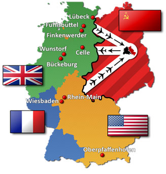 Source:BerlinerBlockadeLuftwege, Leerlaufprzess, Wikimedia
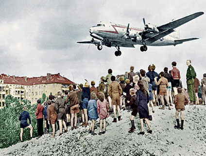
Joseph Stalin did not attack the flights in and out of West Berlin. Below is an actual photograph of a U.S. Air Force plane flying over western Berlin.
In 1949, Stalin lifted the blockade. Germany remained divided, however, between East and West, and Berlin remained a divided city.

 Watch the following film (9:10) on the Berlin Airlift and takes notes as you watch it.
Source: Germany after WWII, AIHE, Teacher Tube