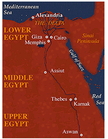
Source: Map of the three Egyptian zones, Odyssey Online, Emory University
Source: Map of the three Egyptian zones, Odyssey Online, Emory University
The river valley civilization of Egypt existed between the dates of 2700 B.C. - 672 B.C.
The city of Memphis is located along the Nile River, south of Giza and Cairo. The Nile River flows north into the Mediterranean Sea. Before the river reaches the sea, it branches out into a fan-shaped area of fertile land called a delta.
Each year when the Nile River flooded, it left behind huge amount of rich, black soil for farming. Rich agricultural and mineral resources provided a stable food supply for this civilization. The desert and seas offered protection from invasion, too.
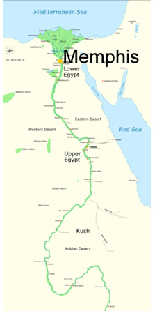
Source: A detailed map of ancient Egyptian settlements along the Nile, Wikimedia
Egyptian cities, like Memphis, became important centers of government and religion. On this map, Memphis is indicated in bold print next to a yellow rectangle. Notice how all the cities in Egypt were located along the Nile River. Also, notice that to the north, west and east of Memphis is desert terrain, and to the north of Memphis is the Mediterranean Sea.
The Egyptians dug out bowl-shaped holes to water their crops. The first Egyptian rulers were called kings. Later, they were called pharaohs. The pharaohs made sure that dams and irrigation canals were built and repaired in order for the land to prosper.