 Divergent Boundaries
Imagine that you are a geographer studying what is below the earth's surface; picture two giant conveyor belts, facing each other but slowly moving in opposite directions. Click on the link below to see divergent boundaries at work.
This is an example of divergent boundaries which occur along spreading centers where plates are moving apart and new crust is created by magma pushing up from the mantle.
 Click the Divergent Boundaries button to see why they are important for us to study.
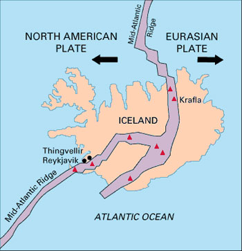
Source: Map of Mid-Atlantic Range splitting Iceland and separating North American Plate and Eurasian Plate, U.S. Geological Survey
The volcanic country of Iceland, which straddles the Mid-Atlantic Ridge, offers scientists a natural laboratory for studying on land the processes also occurring along the submerged parts of a spreading ridge. Iceland is splitting along the spreading center between the North American and Eurasian Plates.
Answer the following question in your notes:
The Mid-Atlantic Ridge moves about 2.5 centimeters per year- this equals 25 kilometers in 1million years! If you were a geographer (or another type of scientist) studying this information:
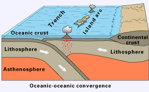
This type of tectonic force occurs where crust is destroyed as one plate dives under another. Depending upon where this plate collision takes place, convergence boundaries form what we know as mountain ranges, volcanic activity, and even earthquakes.
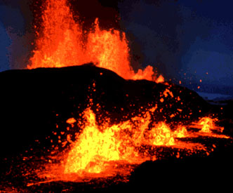
Source: Lava fountains spouting from eruptive fissures during the October 1980 eruption of Krafla Volcano, Gudmundur E. Sigvaldason, U.S. Geological Survey
 Take a look at this news report about a volcano that erupted in Iceland in April of 2010.
Source: Iceland volcano eruption continues, more test flights through ash planned, Russia Today, YouTube
In your notes, complete the following:
To learn more about volcanoes,.
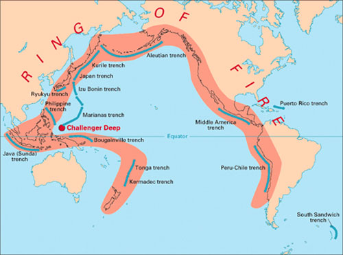
Interactive popup. Assistance may be required.The "Ring of Fire" is an arc stretching from New Zealand, along the eastern edge of Asia, north across the Aleutian Islands of Alaska, and south along the coast of North and South America. The Ring of Fire is composed of over 75% of the world's active and dormant volcanoes.

Earth's size has not changed much during the past 600 million years. Scientists believe this is due to the crust being destroyed at the same rate that it is being created (remember the conveyor belt).
Such destruction (recycling) of crust takes place along convergent boundaries where plates are moving toward each other, and sometimes one plate sinks (subduction) under another. The location where the sinking of a plate occurs is called a subduction zone. As the bottom plate starts to melt, magma rises and forms volcanoes at the surface.
Source: The Convergence of the Nazca and South American Plates, George Erickson, U.S. Geological Survey
Off the coast of South America along the Peru-Chile trench, the oceanic Nazca Plate is pushing into and being subducted under the continental part of the South American Plate. In turn, the overriding South American Plate is being lifted up, creating the towering Andes Mountains (as pictured here), and surrounding ridges, the backbone of the continent. Strong, destructive earthquakes and the rapid uplift of mountain ranges and ridges are common in this region.
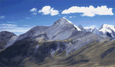
When two continental plates collide, neither one is subducted; also the plates buckle and fold. Sometimes a double thickness of crust results in the formation of mountain ridges. The image to the right is a continental-continental convergence. Look at the example of the continental-continental convergence model here.
Source: Continental-Continental Convergence, U.S. Geographical Survey
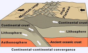
This photo is a sunset view of towering, snow-capped Mt. Everest, a famous peak in the Himalayan Mountain Range in Nepal. The Himalayas, the highest mountains on earth, are an example of convergence collision. The Himalayas rise 1cm per year- that is growth rate of 10km in a million years. Look at the photo below to get an idea of how tectonic forces work over time.
Source: Mt. Everest, from the village of Lobuche (Solu-khumbu), Nepal, Gimmy Park Li, U.S. Geological Survey
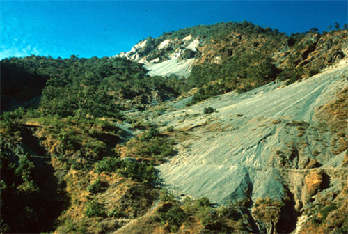
Source: India. Giant talus in the Himalaya foothills near Dehra dun, Sahasradhara, 1964, McKee, U.S. Geological Survey
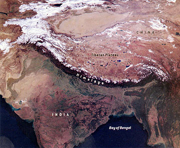
Source: The Himalayan Mountains, NASA
This is a satellite map of Asia, provided by NASA, where the Himalayas are clearly shown.