One particular ocean current is very important to our world; it’s called the Gulf Stream.
![]() Watch this video to learn about Benjamin Franklin’s discovery of the Gulf Stream.
Watch this video to learn about Benjamin Franklin’s discovery of the Gulf Stream.
Source: Ben Franklin and the Gulf Stream, Dyule, YouTube
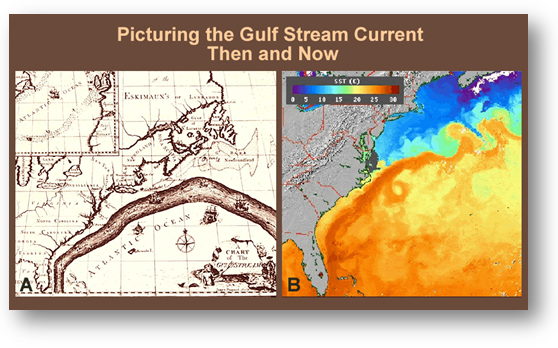
Benjamin Franklin discovered the Gulf Stream while he investigated the delays of European whalers and fishermen who were traveling to the colonies in America. During his investigation and experimentation, he discovered the Gulf Stream. The map that he created is below:

Source: Picturing the Gulf Stream Current: then and now, Windows to the Universe
The Gulf Stream is the warmest water in the satellite image. It reaches from the Caribbean to Delaware before heading east - amazingly the same location where Benjamin Franklin mapped the current by hand over two hundred years before. He used temperature measurements to identify the ocean current. The warmer temperature of the Gulf Stream shows up in satellite images of Sea Surface Temperature data (SSTs). Purple and blue represent the coldest water and orange and red represents the warmest water.
How do we determine the impact of the Gulf Stream on climate?
Before we determine the impact of the Gulf Stream on climate, we must first understand the many factors of climate. Read the following pages very carefully - take notes.

Source: The Remarkables, Free Images
Every place on Earth has weather. However, different places on Earth have different types of "typical" weather. Some places are dry, some are wet, some are hot, some are cold, and some are everything in between!
You can find out what the weather is like where you live by looking out the window or simply going outside. Weather refers to temperature, precipitation (rain and snow), and the wind's direction and speed. Scientists who study the weather collect information from different places on Earth and come up with averages, or typical types of weather, for a particular place. This average, or typical type of weather that occurs during a year, is called the "climate.”