Source: Map, Territorial Growth 1900, PCL Map Collection
By 1850, slavery had become an issue that separated the North and South even further. The tension between the two regions increased as Congress began to consider admitting lands that had been acquired in the West.
In 1849, California requested admission to enter the Union as a free state. This upset those who supported slavery because they realized that admitting a free state would mean more senators from free states would join Congress, thus destroying the balance between free and slave states that had existed since the Missouri Compromise in 1820.
Again, another compromise was reached. The Compromise of 1850 aimed at creating such a balance. The compromise was a series of bills passed mainly to address issues of slavery. According to commentary on the ourdocuments.gov webpage about the Compromise of 1850, "The bills provided for slavery to be decided by popular sovereignty in the admission of new states, prohibited the slave trade in the District of Columbia, settled a Texas boundary dispute, and established a stricter fugitive slave act."
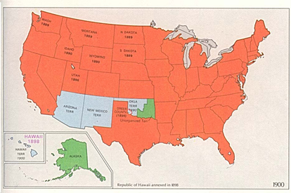
The map below illustrates the boundaries of the United States by 1900.
Source: Map, Territorial Growth 1900, PCL Map Collection
By 1900, the United States had expanded from the Atlantic Ocean west to the Pacfic Ocean. In 1898, the country of Hawaii, located in the middle of the Pacific Ocean, was annexed as a U.S. territory.
→Analyzing the Map: Why do you think that the small country of Hawaii was important to the United States?
Interactive popup. Assistance may be required.
Answer: Hawaii's location in the Pacific Ocean provided the U.S. Navy with a strategic location relative to Asia.