
Just as the establishment of the original 13 English colonies began to shape the growth of America during the 17th century, other historical events contributed to its growth during the 18th century. In this section, you will examine ways in which the landscape of the United States began to change and how the movement of people modified the environment during the 18th century.
European nations were still competing for territory in North America. Spain, France, and England (Great Britain) each held significant portions of this continent as they continued the search for gold and the quest for domination in the new world. The map below illustrates where each held territory as of 1750. Click on the names of the countries in the map key to get a better view of the territories that each country held.

Source: Map, New France, Wikipedia
→ Analyzing the Map: Which European country controlled the most territory? How did England (Great Britain) gain its outlying territories (those in purple)?
Interactive popup. Assistance may be required.
Answer: France controlled most of the land in North America. England gained its outlying areas from France as a result of a treaty between the two countries in 1713.
Along with the competition for territorial control, there were other conflicts that brought about geographical changes to the United States. One conflict had its roots in the competition for land. As the European countries battled for prominence among themselves, they also battled the American Indians who had lived in all the territories for thousands of years prior to the European exploration and colonization. While some American Indians had peaceful relationships with the settlers, there were many others who found themselves in constant conflict with the new settlers who were taking over the land that had belonged to them for generations.
One of the bloodiest conflicts involving the European countries and the American Indians resulted in the French and Indian War. Watch the video to learn more about this conflict.

Source: Video, French and Indian War, Watertown High School, You Tube.
The English were victorious over the French and Spanish in the French and Indian War. The Treaty of Paris (1763) officially brought an end to the French and Indian War, and it ignited the era of English dominance outside of Europe. As part of the Treaty of Paris (1763), England would receive the French land east of the Mississippi River, thus extending its territorial hold.
→ Quick Reflection: How do you think the result of the war changed the boundaries of the map you just studied?
Colonists believed that the war would expand the colonies. The English government had a different idea. A royal proclamation was issued in an effort to ease the fears of the American Indians who felt as if the colonists were driving them out of their land. The proclamation provided that colonists were forbidden to live west of the Appalachian Mountains. The Ohio Valley and all territory from the Ohio to the Mississippi rivers were excluded from settlement in the proclamation.
The map below illustrates the location of the Proclamation Line of 1763. Click on the map to get a better view.
Source: Map, New France, Wikimedia
The map above represents what the country looked like in the year before the American colonists declared their independence from England (1775). The Proclamation of 1763 is believed to be a source of tension between the colonists and the royal government because the colonists believed the boundary was used to keep them from expanding.
Tensions between the American colonists and the English government continued to grow, and after the colonists declared their independence from England, the American colonists became embroiled in the American Revolutionary War. After the colonists claimed victory over the English army, the colonies formed an independent nation; what once was called the 13 English colonies would soon be called the United States of America.
Take a look at the map below. It reflects the changes in this new nation by the end of the 18th century. Refer to your notes and consider what Americans would have known about previous treaties and land acquisition. What lands might these early settlers have wanted to expand into next? Explain why you chose the locations that you identified.
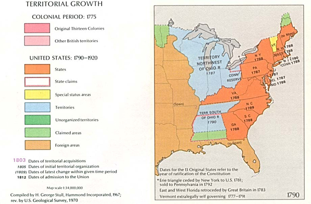
Source: Map, Territorial Growth 1790, PCL Map Collection