 Click on the numbered boxes below to see which Texas cities are on the top ten list.
According to the U.S. Census, Texas is the second most populated state in the United States. The Census further states that from 2000 to 2010 the population of Texas has increased a rate of 20.6 percent. Population increase is just one the factors that have impacted the geography of Texas in the 21st Century.
The increase in population caused the rapid growth of many Texas’ major cities and metropolitan areas. Texas is home to three of the ten most populous cities in the United States (2010). Can you guess which Texas cities are on the top ten list?
Click on the numbered boxes below to see which Texas cities are on the top ten list.
As more people move into the metropolitan areas of Texas, these regions have become popular. Click on each region to learn more.
Think about this: In which region do you live? Would you add additional information about your region? If so, what would you add? Write down your answers in your notes.
It is through these popular regions that we can determine each region’s characteristics. The people, natural geography, and economic activity help define each region.
During the 21st century, Texas has been plagued with several natural disasters. On September 24, 2005, Hurricane Rita hit land near Johnson’s Bayou, Louisiana as a Category 3 storm. The hurricane had an enormous impact on Texas, as well. There was extensive wind damage and flooding to cities in southeast Texas.
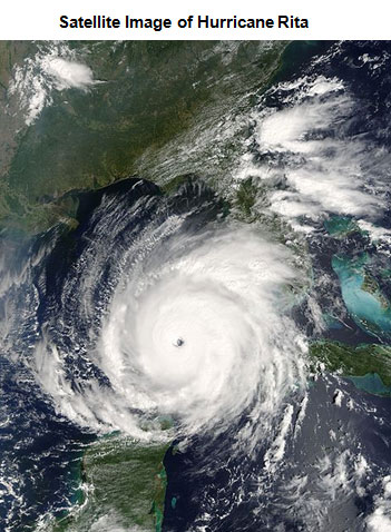
Source: HurricaneRita21Sept05, Jacques Descloitres, MODIS Rapid Response Team, NASA/GSFC, Wikipedia
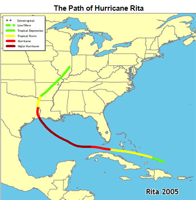
Source: Rita 2005 Map, National Oceanic and Atmospheric Administration
Analyzing the photo: Scroll over the photo to learn more about the evacuation process.
Another major impact that Hurricane Rita had on Texas was the evacuation efforts made in preparation for Hurricane Rita’s landfall. People who lived in Houston were asked to delay evacuation for several days so that people from Louisiana and other southeastern Texas towns could evacuate in time to flee the storm. Not all Houstonians adhered to the requests, and the result was massive traffic jams on all highways leaving from Houston. Traffic on several highways was backed up for hours, causing many to run out of gas as they headed to places like Austin, Dallas, and a few cities in East Texas. The result was a delay of hours, and in some cases, days for evacuees to reach their destination.
Click on the image to access the interactive graphic.
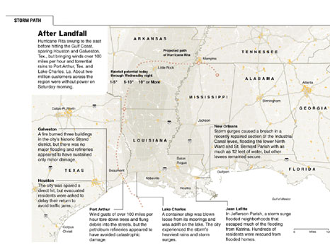
Source: 20050923 Rita Graphic, New York Times
Hurricane Rita caused approximately $10 billion in property damage, and seven deaths were attributed to the hurricane.
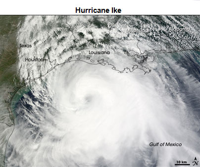
Source: Ike TMO 2008256, NASA
On September 1, 2008, another massive hurricane made landfall near Galveston, Texas. Hurricane Ike, a Category 2 storm, brought massive winds and flooding to the Texas coastal areas. Hurricane Ike caused nearly $6.9 billion in damages. Twenty deaths were attributed to Hurricane Ike.
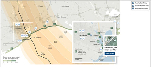
Source: In Ike’s Wake, New York Times
Click on the above image to access the interactive map.
Scroll over the map above to see videos and photos, and listen to audio clips regarding the impact of Hurricane Ike. Using the interactive map above, complete the following questions in your notes.
Interactive popup. Assistance may be required.
Hurricane Ike destroyed most homes near Crystal Beach.
Interactive popup. Assistance may be required.
Floodwaters limited rescue efforts on Bolivar Peninsula.
Interactive popup. Assistance may be required.
The seawall protected most of Galveston’s downtown district. According to the photo, several businesses located outside of the seawall were destroyed.
Interactive popup. Assistance may be required.
Houston experienced high winds, loss of electricity, and some flooding.
Sources for images used in the above interactives: