The ________________ of an area might be expressed as 26.8 people per square mile.
A. population pyramid
Incorrect. A population pyramid is a pictorial representation that involves the age, gender, and number of people that live in that region.
B. population density
Correct! Population Density is the number of people that are found in a specific area. It is calculated by dividing the total amount of land area by the total population of that same region.
C. infrastructure
Incorrect. The infrastructure refers to the highway system and other support systems within a region.
D. GNP
Incorrect. GNP refers to the Gross National Product, the value of goods and services produced in a region.
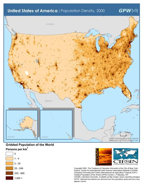
What region in the United States has the highest population density?
A. southwest
Incorrect. The Southeast is not the region of the United States that has the highest population density. There is a region that has a much more dense population.
B. west
Incorrect. The West is sparsely populated.
C. midwest
Incorrect. The Midwest is sparsely populated when compared to other regions of the United States.
D. northeast
Correct! The Northeast is densely populated due to the fact that millions of people that live in a relatively small area of land. This region is the location of some of our largest cities such as New York City, Boston, and Philadelphia.
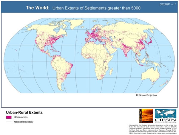
The geographic distribution of cities is most abundant along _______________.
A. mountain systems
Incorrect. Mountain systems are not accommodating for humans to settle and sustain life.
B. major waterways
Correct! Major waterways are a necessary resource that must be present for people to settle in a region.
C. desert lowlands
Incorrect. Desert lowlands are not an ecosystem that is friendly for people to settle, it creates a harsh living environment for people.
D. coastal wetlands
Incorrect. Coastal wetlands are not as suitable for settlement as are locations with major waterways.
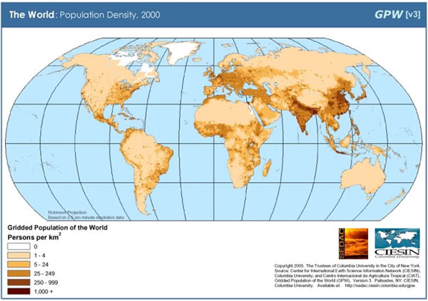
Which continent has a higher overall population density than South America?
A. North America
Incorrect. North America is not more densely populated than South America due to the fact that most of Canada is sparsely populated.
B. Africa
Incorrect. Africa has numerous areas that are yellow which represents sparsely populated areas due to the harsh ecosystems of deserts and rain forest.
C. Australia
Incorrect. The entire continent of Australia is sparsely populated due to the harsh conditions.
D. Europe
Correct! Europe is extremely populated and is represented by 250 or more people per square mile.
Two of the most densely populated areas of the world are ________________.
A. the eastern parts of North America and Asia
Correct! The eastern part of North America and Asia have the most red dots of the regions that were given as choices which means they are the most densely populated areas.
B. the northern parts of North America and Asia
Incorrect. The northern part of North America includes Canada which is sparsely populated.
C. the southern parts of South America and Australia
Incorrect. The southern parts of both South America and Australia do not have many red dots which represent 100,000 people, which means these regions are sparsely populated.
D. the central parts of South America and Australia
Incorrect. The central part of South America and all of Australia is represented by yellow which indicates it is sparsely populated.